GRID TRANSPARENCY
Connected GIS
Full connectivity and complete situational awareness over LV & MV parts of the grid with zero smart meter requirements.
DELIVERED IN WEEKS
The Connected GIS grid module built upon the GIS2Graph technology by Sensewaves, relies on advanced AI proprietary algorithms that can use only GIS to automatically produce an enhanced GIS including all relational data between assets.
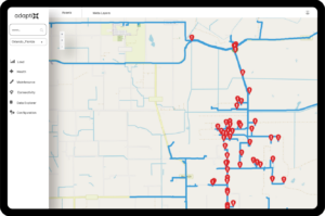
Connected GIS can resolve any grid connectivity issues that a DSO might have, from inferring missing, intermittent connectivity problems to building a full computable grid model from scratch. Moving beyond the need to rely on existing connectivity information, Connected GIS can effectively operate solely on GIS data to automatically infer connectivity and provide visibility to the ‘darkest’ parts of the grid where few or no smart meters are deployed. Additionally, its computable grid model is designed to provide a complete connectivity representation of the distribution grid by encompassing not just some but ALL asset categories (secondary/primary cables, overhead lines, switches, poles, etc.) thus enabling power path proofing in the entire distribution grid area.
The inferred connectivity and the fully computable grid model can be delivered in a matter of weeks, even in the case of large electricity networks serving more than 1M customers. That’s a fraction of the time needed compared to manual or semi-automatic calculations. Furthermore, the Connected GIS module is bridged with the operators’ GIS to ensure the continuous update of the connected GIS model based on the evolution of the grid and the GIS data updates.
- 95% and above accuracy of performance at resolving and/or completing connectivity for LV networks (tested in rural and urban grids)
- 99.5% for MV networks
![]()
Features
- Inference of Connected, Verified LV and MV electricity model and single line diagram.
- Automatic verification of network connectivity.
- Circuit top-down and bottom-up queries, electricity path inference.
- Phase inference and phase verification.
- Asset relationship verification.
- Outage localization.
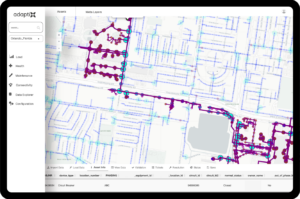
- Map based GUI for easy use, and visual presentation of data and issues in-app GIS data corrections.
- Integration with Utility tools( GIS, planning, ERP).
![]()
Benefits
- Improved or built-from-scratch connectivity / network visibility and situational awareness of the network.
- Understanding of connections and loads allowing improved network balancing.
- Optimized damage assessment after outages (due to storms or other factors).
- GIS data verification, correction and enrichment.
- Improved LV network modelling capability, accelerated system expansion, EV and DER integration- Integration with grid planning software.
- Improved scenario (what-if) analysis of investment planning, proactive maintenance – Integration with ERP software.
- Enablement of technical and non-technical losses detection.